Water Cycle & Weather Exam Review Notes
(Fri. May 10th)
Part One: Water Cycle
Directions: Students should be able to draw a diagram of the water cycle and include the following:
A. Landforms
1. Ocean (water source)
2. Sun (heat source/energy)
3. Clouds
4. Mountains
5. Hills
6. Plains
7. Beach
B. Processes
1. Evaporation
2. Condensation
3. (wind blows clouds over the land, ex. Marine Layer)
4. Pt. of Saturation
5. Precipitation
6. Lowest temp. to Highest temp. (hail, snow, sleet, rain, fog)
7a. Run Off (above ground)
7b. Ground water (below ground)
*Cycle begins again at the ocean
C. Special Terms
For ground water
Layers (porosity= the ability of the water to drain through rocks and pebbles)
If porosity is low, then a flood could result.
1. Zone of Aeration
2. Water Table
3. Zone of Saturation
4. Bedrock
D. Special Terms (Use Chapter 10)
For Runoff
1. Oxbow lake
2. Meander
3. U valley
4. Beach
5. Delta
6. Flood Plain
7. Tributary
8. Springs (areas of ground water that seep to the surface)
9. Channel
10. Aquifer
Text book Reference
Water Cycle (pg. 249)
Examples of Rivers Meandering (pg 252-254)
Part Two: Weather
Directions: Students will view a weather report and should be able to identify the following:
1. High & Low Temperature
2. Air Currents (Fronts: Warm/Cold, High Pressure/Low Pressure)
3. Humidity
4. Chance of Precipitation
5. Type of Precipitation
6. Barometric Pressure
7. Wind Speed & Direction
Volcano & Earthquake Exam Review Notes
(Wed., January 23rd)
Part One: Volcano Types (Chapter 8 Highlights on p.g 206 & 207)
1. Students should be able to identify volcano types based on their characteristics.
a. cinder: eruptions are mostly smoke & ashes (cinder) Typically taller than
most volcanoes and shaped like a cone.
b. dome: round or broad top, smooth surface, slow moving lava
c. stratovolcano/composite: violent eruption, viscous lava flow, pyroclastic
flows
d. shield: typically under water, create islands
2. Students should be able to identify one volcano that is categorized in each type.
a. cinder: Wizard Island
b. dome: Lassen Peak
c. stratovolcano/composite: Mt. Fiji
d. shield: Mauna Loa
3. Students should be able to predict the type of rock that will result from various volcano eruptions.
(Review the Discovery Education science exploration, "Chill Out, Rock On")
The following factors will determine the outcome of the rock type.
a. Magma Type: Basaltic or Granitic
b. Rate of Cooling: Slow or Fast
c. Location of Rock Formation: Extrusive (above ground)
or Intrusive (below ground)
Part Two: Earthquake Vocabulary (Chapter 9 Highlights on pg. 184 &185)
Students should be able to comprehend the major terms associated with earthquakes.
1. seismology
2. fault
3. deformation
4. elastic rebound
5. seismic waves
6. p waves
7. s waves
8. seismograph
9. seismogram
10. epicenter
11. focus
12. gap hypothesis
13. seismic gap
14. Moho
15. shadow zone
Part Three: Calculate the epicenter
Students should be able to calculate the epicenter given three points on a map and the time at which each city registered the primary and secondary waves. Please use the Discovery Education Science Exploration, "Find the Tremblor"
Part Four: Short Answer
1. Describe the importance of earthquake safety. What should you do in the event of an earthquake? What factors influence the stability of a building during an earthquake?
2. What is the relationship between earthquakes and volcanoes? What is the result of divergent, convergent and transform boundaries? Describe the boundary that we currently reside over in Los Angeles.
Models of the Earth Exam Review Notes
ATTENTION EARTH SCIENCE STUDENTS! DUE TO ITBS TESTING, THE EARTH'S MODELS EXAM WILL BE POSTPONED UNTIL MONDAY, OCTOBER 1ST. PLEASE MAKE NOTE OF THIS CHANGE IN YOUR AGENDA!
Part One: Maps as Models
1. Students should be able to identify the major types of models of the Earth.
Students will be given examples of each projection. They must be able to identify the map by examining the picture. Students must also be able to describe how each projection is created. Students should be prepared to discuss the pros and cons of each model/projection. The major models/projections of the earth are:
a. Globe
b. Azimuthal
c. Conic
d. Mercator
e. Aerial
f. Topographic
Please view the examples and descriptions below. You can also use your text book for a description of each map type.
2. Students will be given a diagram of a topographic map. Students should be able to identify points of elevation within the maps by examining the contour lines of the maps.
Globe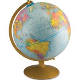
A globe is the only 3-D model of the world. It is the most accurate model however it is not practical for daily use in that students would not readily carry around globe. Conic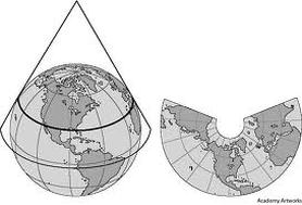
This family of projection uses a cone as its projection surface. Often the apex of the cone is aligned with the polar axis of the sphere, resulting in a polar projection. The results in relatively simple to generate maps with good levels of accuracy, particularly in mid to high latitude regions. The issue with this type of projection lies at the equator. The equator is grossly distorted. Topographic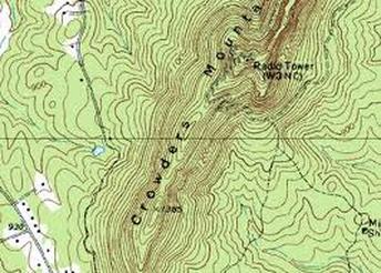
A map is a way of representing on a two-dimensional surface, (a paper, a computer monitor, etc.) or any real-world location or object. Many maps only deal with the two-dimensional location of an object without taking into account its elevation. Topographic maps on the other hand do deal with the third dimension by using contour lines to show elevation change on the surface of the earth, (or below the surface of the ocean). |
Azimuthal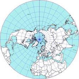
An Azimuthal map projection takes a cross section of the globe. Imagine taking a globe and slicing it into thin pieces, starting at the pole. The resulting projection is a circular map of that particular cross section. Unfortunately an Azimuthal projection could never display the Earth in its entirety. Mercator (Cylindrical)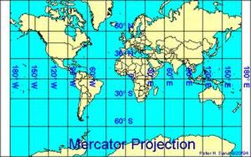
In a typical cylindrical projection, one imagines the paper to be wrapped as a cylinder around the globe, tangent to it along the equator.the Mercator projection the parallels of latitude, which on the globe are equal distances apart, are drawn with increasing separation as their distance from the equator increases in order to preserve shapes. However, the price paid for preserving shapes is that areas are exaggerated with increasing distance from the equator. The effect is most pronounced near the poles; e.g., Greenland is shown with enormously exaggerated size, although its shape in small sections is preserved. The poles themselves cannot be shown on the Mercator projection. Students using the Mercator projection obtain an incorrect impression of the relative sizes of the countries of the world.
Aerial
An aerial map projection are actual pictures of a particular area taken from above. Aerial projection allows you to see the most detail however an aerial of the entire surface of the Earth can not be taken. Also the higher the elevation, the less detail the aerial map will be able to display. |
Part Two: Understanding Maps
1. Students should be able to identify the following parts of a map:
a. compass (north, south, east, west)
b. scale (ie. 1mile = 2 inches)
c. equator
d. prime meridian
e. longitude lines
f. latitude lines
g. legend
2. Using a map, students should be able to answer questions involving points on a map and distances
For example: If the scale is 1 mile = 2 inches then what is the actual distance between two cities if the measured distance on the map is 30 inches? 30/2= 15 miles
For example: What city is 42 degrees West longitude and 90 degrees South latitude? (map will be present for student use)
3. Students should be able to identify the continents and major oceans of the Earth.
